

_edited.jpg)
HONORING LEGACIES OF VETERAN SERVICE

RECENT DISASTERS
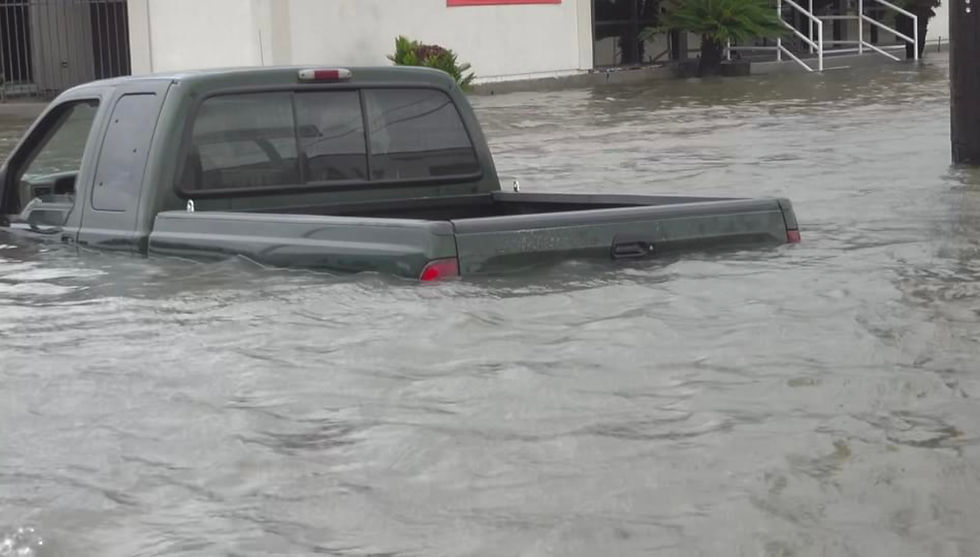
Hurricane Melissa
OCT 28 - Current
This hurricane came later in the season than most, and is the second strongest ever recorded Category 5 in the modern era!
We are organizing continual Relief Efforts for the island and anticipate long-term contact in the region. Impacts are ranging from light home damage in the easter portion of the island state, to complete devastation in the west. More updates to come, as well as photos.

Hurricane Melissa.
Photo credit: CBC


Screenshots via Video.
Video Credit:
Collaborator L.R.J.
*Unable to upload short
Hurricane Helene
SEP 24 - SEP 29 2024
This storm caused major damage to several states.
Here is our active deployment breakdown.
Days Active: 25 SEP - 5 OCT (11 days) Hours on the Ground: 90 Mileage: 1,260 Regions served: ● Steinhatchee, FL ● Perry, FL ● Cross City, FL ● Horseshoe Beach, FL ● Asheville, NC ● Black Mountain, NC ● Fletcher, NC ● Biltmore Forest, NC ● Hendersonville, NC ● Royal Pines, NC ● Swannanoa, NC
Total Rescues: 72
Total evacuations without Rescue: 131
Total Lives Impacted: 203
SUMMARY: Hurricane Helene made landfall one-hour east of Tallahassee, within the big bend of Florida. The rescue team, originally deployed to Tallahassee, made our way down route 19 at 18:31 on 25 SEP, with our first active rescue occurring at 19:10. Operations continued at a 3 per hour rescue pace for 16 rescue hours.
On 30 SEP, we were notified that western North Carolina was in an all-hands S.O.S. situation. Thus, we packed up the team and headed north to Asheville, NC. [9-hour total drive time].
On the ground in western counties, we joined with other active teams under constant deployment for +60 hours.
We then branched out as waters receded and mudslides ceased to secure spot deployments between various cities for 14 hours.
Actual operations extended through 05 OCT for dire calls.

Hurricane Helene. Photo credit: Associated Press
Video from Fox Digital:

Team Lead Clip:

Hurricane Debby
AUG 5 - AUG 10, 2024
Hurricane Debby struck Florida as a Category one storm before re-emerging as a strong tropical storm and slowly trudging along the southeastern coast. For four days it made contact with Charleston, South Carolina and slowly crept up the eastern seaboard, devastating residents.
Within the first 6-hours we had our first 17 low water rescues and we witnessed the lowland homes being inundated with high levels of ocean surge.
Many families lost their life belongings for many miles around the Charleston Harbor, James Island and Mount Pleasant [which were the areas we navigated with several other teams and local first responders] as well as other cities and states.
Our initial plan was to make it down to Tallahassee, Florida as the storm was initially Hurricane Debby, but the National Weather Service's report showed us that South Carolina would be more optimal as the storm would not make direct landfall in a heavily populated city.
It is estimated that thousands of homes suffered catastrophic damage in the Charleston County area, while overall tens of thousands were flooded by the storm and some suffered damage by its spinoff tornados nationwide. Storm flooding occurred all the way into New York and Maine, while flash flooding and drainage lasted through the AUG 11th weekend.

Tropical Storm Debby (from Detroit Free Press)
Video from CBS Mornings:

Video from WBTV-3 News:


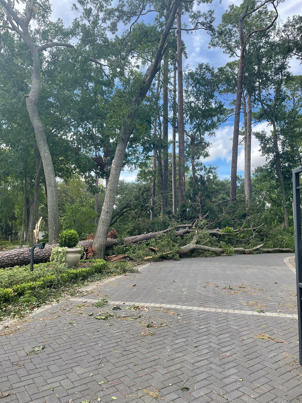
Hurricane Beryl-
JUN 28 - JUL 11, 2024
This deceptive storm gained Category 5 status in the Caribbean before decimating Cariccou and Jamaica.
It later hit the Bay of Campeche causing significant damage.
From there the path altered sharply and turned northward, causing it to have more time to redevelop before striking south of Houston, TX as a Category 1 hurricane.
The U.S. Veterans Hall of Fame stayed for 94 total hours and received a total of three rescue assignments. We also assisted with several recovery efforts by way of tree removal and filing reports for citizens who did not have the means to do so.
Two weeks after the storm hundreds of thousands of homes and businesses (mainly in Texas) lacked electricity, as the infrastructure proved no match for the storm's intensity.

Hurricane Beryl (from WikiPedia)

Hurricane Idalia-
AUG 26 - AUG 31, 2023
Thankfully, God allowed this storm to hit while it was trying to ramp up its strength. In the process of trying to gather itself, it didn't have enough time to fully regain it's eyewall and only hit as a low-end category 3. Had it stalled for a few hours, it would have easily been a Category 4 or higher.
Devastation in low lying areas and coastal towns was still catastrophic just due to the storms surge and constant hightide.
Rescue efforts by V.E.R.U. began August 3 and continued through September 3rd. As with previous operations as volunteers, we remain in coordination with local county sheriffs and city workers.

Hurricane Idalia (from USA Today)


Hurricane Ian -
Sep 28 - Oct 2, 2022
This Category 4 hurricane had a very peculiar track as it was initially supposed to hit the southern edge of Florida and the go west into the Gulf of Mexico: however, it had its own plan and took a devastating and somewhat unexpected turn north on the western shores of the state and made landfall in the general area of Ft Myers.
Outlying areas such as Iona and Sanibel Island were completely decimated.
Towns like Arcadia were completely submerged.
The storm then headed East over the state and continued its deadly journey into the east-northeastern parts of the state.
Cities and towns along the St. Johns River (which flows north) were saturated and left completely inaccessible.
Our team was on the ground for a total of 6 days and completed almost 40 rescue operations, 3 structure security details and one light recon.
Months later, right before the holidays, it was noted that many towns were still submerged in water in some areas.
Sadly, this storm claimed 157 lives between Cuba and the United States.

Hurricane Ian (*photo from WikiPedia)


Hurricane Ida -
August 29, 2021
This Category 4 hurricane broke records for formation as it collected within 48 hours: disallowing time for proper evacuation orders.
Within one hour of arrival, our team was being battered by 55 mph winds and by evening were sitting out a storm with 145 mph sustained winds and whipping rain..
The first fatality was reported within the first 24 hours as a man was crushed by a tree.
The next morning the team was doing rescues in low water, low-lying areas of the lower 9th ward in New Orleans and were later dispatched to assist with efforts in Metairie, Louisiana.
Later that same day, distress calls were pouring in from LaPlace, LA and the St. John the Baptist Parish.
Collaborative efforts (of multiple rescue units) resulted in thousands of rescues over the next week.
Our team left 11 days later with conditions in southern Louisiana as: residents have no electricity in 85% of the southern areas, no running water and major food necessities.

Hurricane Ida AUG 29 2021 (formed AUG 26)
Link #2: https://youtu.be/YiUfyD1acZA
Hurricane Sally -
September 11, 2020
The US Veterans Hall of Fame rescue team was initially stationed in the western portions of Louisiana assisting with the evacuees and victims of Hurricane Laura when the siren sounded for this storm.
As 2020 has shown, Murphy's law had this storm forecast for portions of Louisiana and Mississippi.
As the team hunkered down and helped residents prepare for new waves of rain and wind the storm took a turn, providing relief for states already drenched and worn, but causing fear for those in the neighboring states of Alabama and Florida, as well as some near Gulfport.
Early September 10th the storm died down to a Category 1 hurricane, but in the later hours of the day it revved up to a strong Category 3 storm that flooded and damaged cities from Mobile, AL to Pensacola, FL and from Gulf Breeze over to parts of Panama City (Bay County).
Storm surges as high as 15 feet were recorded in some areas.


*photo credit News 4 Jacksonville


Hurricane Laura -
August 27, 2020
This storms track was initially forecast as a lower to mid-level category 2 landfall. However, perfect water temperatures and little wind-sheer gave Laura favorable conditions of strengthening to a upper level Category 4 storm overnight. Sustained wind speeds of 140 mph were reached just before landfall and gusts up to 150 were recorded.
The towns of Cameron and Lake Charles Louisiana took the brunt of the storm as the eye-wall crashed into the cities at around 1:00 a.m. Several coastal towns along the Louisiana and Texas border suffered catastrophic damage as this unrelenting storm wreaked havoc in the dark of night. Storm surge as high as 15 feet were recorded as well: as witnessed in Cameron, LA. Two story homes were submerged and remain with some surrounding water today. Initially close to 900,000 lost power as well.
Rescue operations were slowed due to COVID-19 protocol, yet successful.

*photo credit the Independent

Additional Video References
Video One : Home Evacuation Prep
Video Two : Recap
Video Three: Airport Condition
Video Four: Community College
*Click links to watch
Hurricane Dorian -
August 24th 2019
Dorian was originally expected and forecast to be a fast moving, low-category storm, but those forecast were quickly done away with as the storm seemingly stalled in the Atlantic and maneuvered through the Caribbean Islands while growing stronger.
The storm was forecast as well to be a Category 2, and potentially a Category 3, as it pushed towards Puerto Rico, but again it curved around expectations and only side swiped the large island and slowed more at sea.
A few days later, Dorian grew to an unprecedented Category 5 with sustained winds of over 185 mph and gusts up to 225 mph.
In it's sights were the islands of the Bahamas.
Grand Bahama Island and the Abaco Islands would see devastation like never before as the storm crept slowly at speeds between 2 and 8 mph over the course of two straight days. Hundreds were reported dead and thousands missing.
Only when a front from the west pushed it's way through would the storm finally turn north and head for the U.S. eastern coast.
A weakened Category 2 to low Category 3 storm would skirt Georgia and the Carolina's (namely Charleston and the Myrtle Beach regions) for three days only lightly flooding some areas, but with several reports of tornadoes, high wind gusts and the aftermath of trees and power-lines down.
Ocracoke Island would be the U.S. highest casualty of the event with severe flooding washing out roads and ports, leaving hundreds stranded on the island to wait out the storm.

Hurricane Dorian SEPTEMBER 2019
DISASTER RELIEF DRIVES
The US Veterans Hall of Fame would like to collaborate with your corporate and community associations, year round to collect items for disaster relief efforts that impact our nation.
Please send us an email with the subject "Disaster Relief" today so that we can find ways to attach to your passion project of relief efforts!
Hurricane Michael -
OCT 7th, 2018
This storm quickly set records as it grew in size, speed, velocity and range in it's first 72 hours: quickly identifying as a Category 5 hurricane aiming at the Florida Panhandle, Southern Georgia and the entire Gulf Coast.
By the time evacuations were mandated the storm had picked up enough speed to catch the tail-ends of evacuees, trapping many in place.
Much of southern Georgia and Florida were left without power and clean water and cities such as Panama City, Mexico Beach and others were completely decimated in 36 hours or less from wind speeds clocked at 150 mph.
Tornado's were spotted within the storm as well: hidden by torrential rain and cloud cover.
Thirty-plus fatalities were initially reported within the first 24 hours post-landfall and hundreds were reported missing within the first 5 days, with many families not knowing whether or not their loved ones had evacuated.
Rescue efforts by V.E.R.U. began October 9th and continue through the holiday season of 2018. As with previous operations as volunteers, we remain in coordination with local county sheriffs.

Hurricane Michael OCT 2018


6 Months After Hurricane Michael
- April 14, 2019
Hurricane Florence -
SEPT 13, 2018
This storm started off as a potential Category 3 hurricane that hurdled towards the eastern United States coast. On the eve of it's landfall, the storm was downgraded to a lower level Category 1 storm.
More surprisingly, the storm took an unpredictable change in speed and hovered over the eastern fringe of North Carolina for 5 straight days, dumping torrential rain on cities stretching from New Bern, NC to Swansboro, NC and making a catastrophic impact on Wilmington by heaving up to 5 feet of rain in some areas.
Geographically the storm was a nightmare as the cities geological structure are a natural "bowl" in shape and the rain had little chance of draining out into the Atlantic quickly. This caused more permanent damage to towns and cities as reservoirs and streams backed up and flooded inland for hundreds of miles.
Rescue efforts by V.E.R.U. expanded from 2 day operations to 8 day operations as volunteers, in coordination with local county sheriffs.
